

On this page
Argo data is free, open, and available without registration. The difficulty is not access — it is that the archive offers the same measurements through several routes and in several file layouts, and picking the wrong one means downloading gigabytes to answer a question that a text file could have answered.
If you are new to what an Argo float is and what it measures, start with What is Argo Float? A Complete Guide to Ocean Observation Data.
The Source: Two Global Data Assembly Centres
All Argo data flows to two Global Data Assembly Centres, which hold identical content:
- The Coriolis GDAC in France, at
https://data-argo.ifremer.fr/ - The US GDAC, at
https://nrlgodae1.nrlmry.navy.mil/pub/outgoing/argo
They mirror each other, so pick whichever is closer or faster for you. Every other Argo service — regional portals, viewers, Python libraries, cloud copies — is a view onto this content. When two sources disagree, the GDAC is what settles it.
The same content is reachable through several protocols:
| Route | Best for |
|---|---|
| HTTPS | Browsing, and scripted downloads of specific files |
| FTP | The same tree; still documented, but browsers no longer open it |
rsync (vdmzrs.ifremer.fr) | Keeping a local mirror in sync without re-downloading |
| ERDDAP and THREDDS | Server-side subsetting, so you receive only the rows you asked for |
| AWS Open Data | Cloud-side analysis without moving the archive |
For a first look at a handful of profiles, HTTPS is enough. rsync becomes worthwhile once you are maintaining a local copy; ERDDAP becomes worthwhile once the subset you want is much smaller than the files that contain it.
How the Archive Is Organised
The top level of a GDAC holds a small number of directories and a set of index files:
dac/           every float, grouped by the data centre that processes it
geo/           the same profiles, grouped by ocean basin and date
latest_data/   recently updated files
aux/           experimental and auxiliary sensor data
etc/           supporting files
*.txt          index files, plus readme_before_using_the_data.txt
dac/ and geo/ contain the same observations arranged differently. Use dac/ when you know which float you want; use geo/ when you know which region and period you want.
Inside a float’s directory you will find its whole history:
dac/aoml/1900722/
    1900722_meta.nc      float and sensor metadata
    1900722_tech.nc      engineering and technical values
    1900722_Dtraj.nc     delayed-mode trajectory
    1900722_Rtraj.nc     real-time trajectory
    1900722_prof.nc      all core profiles in one file
    1900722_Sprof.nc     all synthetic BGC profiles in one file
    profiles/            one file per profile
Which File Type Answers Your Question
The naming convention carries real information. The first letter is the processing state: R for real-time, D for delayed mode after expert quality control. A B prefix marks a biogeochemical file, and S marks a synthetic profile.
| You want | Download |
|---|---|
| One float’s temperature and salinity history | <WMO>_prof.nc |
| One specific profile | profiles/D<WMO>_<cycle>.nc |
| Biogeochemical variables on one pressure axis | <WMO>_Sprof.nc |
| Where the float drifted between profiles | <WMO>_Dtraj.nc or <WMO>_Rtraj.nc |
| Sensor models, calibration, mission configuration | <WMO>_meta.nc |
The multi-profile file (_prof.nc) is the one most people should start with. It packs every cycle of a float into a single download, so following one float over time is one file rather than two hundred.
For biogeochemical work, the synthetic profile file (_Sprof.nc) is usually the right choice. BGC floats often sample each sensor on its own vertical scheme, so in the raw files oxygen and chlorophyll can sit on different pressure levels from each other and from the CTD’s temperature and salinity. The synthetic file aligns the core and biogeochemical parameters onto one axis per profile, which removes a whole class of merging work.
If the internal structure of these files is the part you are stuck on, Argo NetCDF Format Explained for Beginners works through it.
Use the Index Files Before You Download Anything
The index files are an easy part of the archive to overlook. Each is a plain CSV listing every file of one type with enough metadata to filter on. The per-float indexes are a few megabytes, and even the largest — the core profile index — is around 300 MB, or 60 MB gzipped: orders of magnitude smaller than the terabytes it describes.
| Index file | Lists |
|---|---|
ar_index_global_prof.txt | every core profile file |
argo_synthetic-profile_index.txt | every synthetic BGC profile file |
argo_bio-profile_index.txt | every B-file |
ar_index_global_meta.txt, _tech.txt, _traj.txt | metadata, technical, and trajectory files |
ar_index_this_week_prof.txt | profiles added or updated in the past week |
The core profile index has one row per file:
file,date,latitude,longitude,ocean,profiler_type,institution,date_update
aoml/1900830/profiles/D1900830_002.nc,20090515031347,-5.654,42.314,I,846,AO,20260805230652
In the real file, these column headings are preceded by several # comment lines, so skip them when you parse it (comment="#" in pandas).
That is enough to answer “which profiles exist in this box, in this date range” with a text filter, and to end up with a list of exact file paths to fetch.
The synthetic index adds two columns that make BGC searches straightforward:
file,date,latitude,longitude,ocean,profiler_type,institution,parameters,parameter_data_mode,date_update
aoml/1900722/profiles/SD1900722_001.nc,20061022021624,-40.316,73.389,I,846,AO,PRES TEMP PSAL DOXY,DDDD,20220628080801
The parameters column lists which variables the profile actually contains, and parameter_data_mode gives the processing state of each one in the same order. Selecting profiles that carry DOXY in delayed mode is a filter on this file, not a download-and-inspect loop.
Browser Tools When You Do Not Want to Script
Several official and community tools sit on top of the GDAC and are the faster route when your search is exploratory:
- The Euro-Argo Data Selection tool searches by region, date, float, and parameter and produces a download.
- The Argo Fleet Monitoring dashboard is the quickest way to look up a specific float’s status and history from its WMO ID.
- The US GDAC provides a profile selection form over the same archive.
- Argovis offers a map-based browser and an API for automated retrieval.
Real-Time or Delayed Mode?
Every profile appears first in real time, typically within a day, having passed automated checks only. Delayed-mode files appear later — commonly a year or more after collection for core Argo — after an expert has examined the profile and corrected sensor drift.
Choose by what the data has to support. For screening, teaching, or deciding whether a float is relevant, real-time data is fine. For anything sensitive to small salinity or pressure bias — heat content, mixed layer depth trends, water mass analysis — use delayed-mode files and the adjusted variables inside them. Argo Data Quality Control covers how to make that choice inside a file.
A mixed download is normal. A float’s recent cycles will be real-time while its older ones are delayed mode, and the data mode is recorded per profile so you can tell them apart.
Citing What You Downloaded
The GDAC changes daily as delayed-mode processing catches up, which makes “downloaded from the GDAC” an unreproducible statement. Since 2014 a monthly snapshot of the whole archive has been assigned a DOI, and citing the snapshot you actually used is what makes the analysis repeatable. The snapshots are collected under doi.org/10.17882/42182. The Argo data policy also asks that you acknowledge the programme.
Deciding What Is Worth Downloading
The index files tell you which profiles exist. They do not tell you which ones are interesting, and that is usually the real question — whether a region has the structure you are looking for, whether a float’s cycles are similar or changing, whether an oxygen feature is present before you commit to a workflow around it.
Looking at profiles interactively answers that faster than a download-and-plot loop, and it narrows the list of WMO IDs and cycles you then fetch from the GDAC.
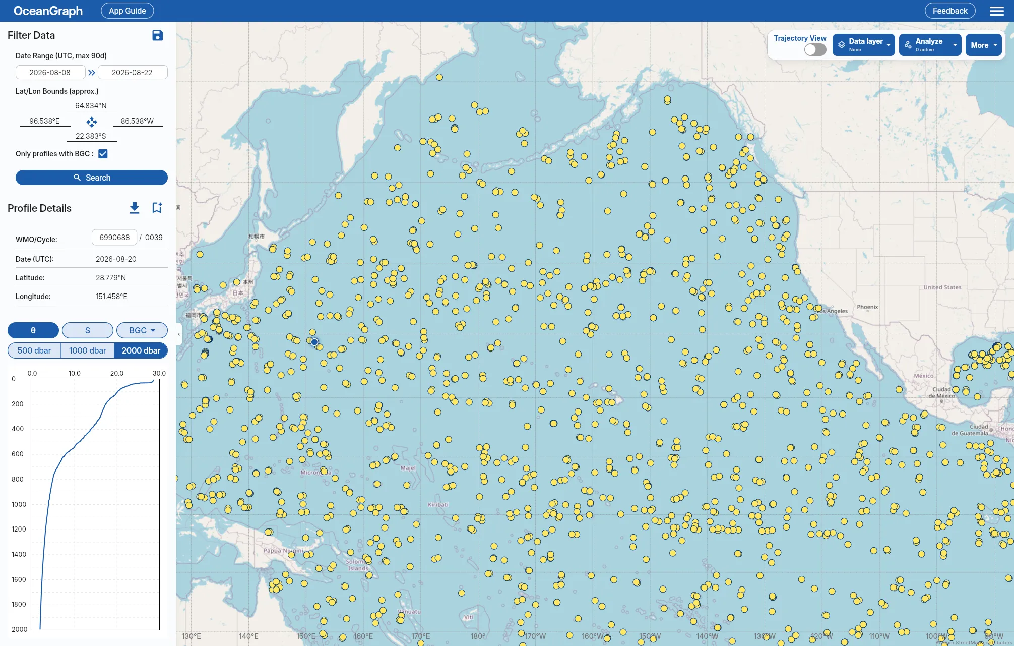
Once you know which floats and cycles matter, the search logic in Finding Argo Float Profiles by Location, Time, and WMO ID maps directly onto the index columns above.